Buying or Selling Near Pahrump’s Planned Growth? Check What’s Actually Approved
By Jeannette Draper, REALTOR® · October 16, 2026
Records reviewed October 16, 2026
County decisions involving Wilson Ranch and Mountain Falls South give Pahrump buyers and sellers useful information about planned growth. The practical questions are what each approval covers, where the affected land is, and what still needs to be checked for a particular property.
Start with the quick answers below, then review the project details and the records linked throughout this article. The approvals discussed here do not establish a construction start date, a utility connection for neighboring acreage, or a change in nearby property values.
Pahrump Planned Growth — FAQs
What did Nye County approve for Wilson Ranch?
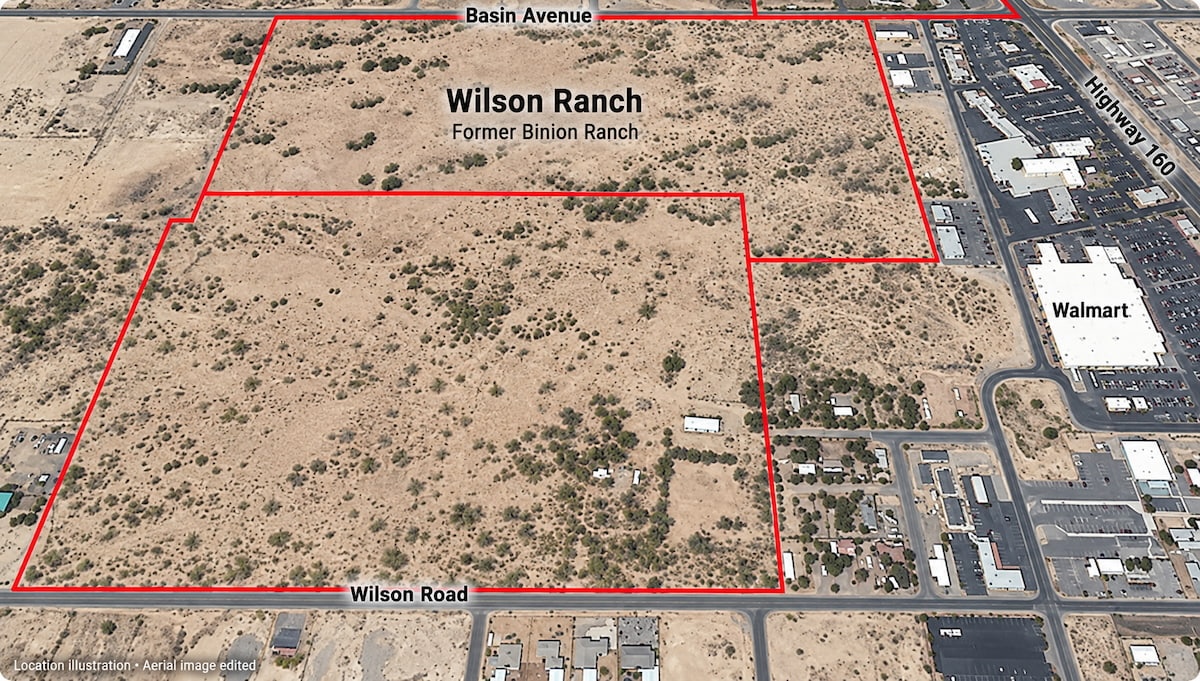
On September 15, 2026, commissioners amended and adopted Bill No. 2026-09 concerning the development agreement with MACKK, LLC. Earlier planning approvals identify the site at 700 E. Wilson Road in Pahrump.
Source: 2026 commission summary, September 15, item 9; 2025 location details below
Are the 62 Mountain Falls South lots the entire development?
No. LD-25-12 covers a specific 14.77-acre subdivision proposal. A separate approved parent tentative map, LD-25-19, describes 29 large parcels across approximately 1,142 acres. Those parent parcels are not a count of individual homes.
Source: 2026 commission summary, April 21, items 18.8 and 18.11
Does an approval tell me when construction will begin?
Not by itself. The approval summaries discussed here do not announce a construction start date. Ask county staff which later maps, permits, engineering approvals, and improvement obligations apply to the phase you are researching. Ask the developer separately about its current schedule.
Source: Nevada Revised Statutes Chapter 278, development agreements and final maps
Must every Mountain Falls South home be one story?
The June decision describes a one-story condition for specified residential areas on parcels sharing a boundary with land outside the common-interest community. It is not a blanket statement about every home. Ask Planning to identify the condition on the map relevant to your property.
Will nearby development bring water or sewer to my property?
The records reviewed do not establish service for neighboring property. For a potential purchase, request parcel-specific confirmation of the provider, available connection, required work, and costs. If a well or septic system is involved, investigate those arrangements separately rather than relying on a subdivision announcement.
Source: Nye County maps, including utility service areas; confirm current information with Planning
How do I check whether a planned project is beside my property?
Use the property’s Assessor’s Parcel Number and compare it with the applicable project map. Ask Planning to help identify the closest phase, adjacent proposed uses, and any shared boundary. For a purchase decision, also review title and survey information as appropriate.
Source: Nye County maps, including subdivision, zoning, and master plan maps
Should buyers rush or sellers raise prices because of an approval?
An approval is not evidence of a particular price increase. A practical approach is to consider the property’s existing features, current comparable sales, and documented surroundings. This article reports no study measuring the projects’ effect on prices or demand, and provides no basis for predicting one.
Where can I check newer decisions or ask about a particular parcel?
Use Nye County’s Meeting Center and contact the Planning Department at (775) 751-4249. Give staff the project name, application number, and property parcel number. Request the latest decision and applicable conditions, rather than relying only on the wording of an agenda.
Source: Nye County Planning assistance and application information
What do the Wilson Ranch records identify
On October 21, 2025, commissioners approved ZCMP-25-9 and PU-25-1 for a proposed mixed-use community on approximately 139 acres at 700 E. Wilson Road. The record identifies APN 035-311-02 and describes single-family, multifamily, and commercial uses. These are the earlier planning applications, separate from the later agreement decision.
Source: 2025 commission summary, October 21, item 12, PDF pages 175–176
For someone considering nearby property, the useful next step is to locate that parcel and review the applicable layout. Ask which proposed use would be closest to the home or land being considered. A general reference to Wilson Road does not establish that a listing adjoins this site.
What do the Mountain Falls South records cover
Commissioners approved the 62-lot tentative map LD-25-12 on April 21, 2026. Its staff report identifies addresses at 6120 E. Mountain Falls Boulevard, 6200 E. Mountain Falls Boulevard, and 5372 S. Nevada Highway 160. The application should be distinguished from the broader parent map mentioned above.
Source: 2026 commission summary, April 21, item 18.8
The April staff report proposes Great Basin Water Company water and sewer connections for the subdivision lots. It says required water rights must be obtained before final-map approval and improvement plans must be approved by Public Works. These describe the proposal and requirements in that report, not a finding that the work has since been completed.
Source: LD-25-12 staff report, April 21, 2026, PDF page 4
The amended agreement decision is dated June 16, 2026, with a stated effective date of July 6, 2026. The meeting date and effective date should remain distinct.
Source: 2026 commission summary, June 16, item 7, PDF page 110
What newer October records show
The October 14, 2026 planning agenda lists SN-26-4, a street-name request for “Mountain Falls & Highway 160 – Phase I” at 6120 E. Mountain Falls Boulevard, APN 045-011-22. It also lists SN-26-5 for “Latitude Las Vegas – Mtn Falls South – Phase 1” at 5371 S. Jane Avenue, APN 045-101-46. These are different items and parcels.
Source: October 14, 2026 Pahrump Regional Planning Commission agenda, items 10–11
That agenda establishes what was scheduled for consideration. It does not establish the vote, approval of the names, or a construction schedule. Anyone following those items should request the recorded outcome. The county explains that approved planning minutes are generally available approximately 30 days after a meeting and a draft may be obtained through Planning.
Source: Pahrump Regional Planning Commission, agendas and minutes guidance
Why the type of approval matters
A development agreement can address permitted uses, building dimensions, infrastructure obligations, and construction phasing. A tentative map and a final recorded map are separate documents. Neither a meeting headline nor a single approval gives a complete picture of the project.
Source: Nevada Revised Statutes 278.0201 and 278.360–278.378
It is also inaccurate to assume every required improvement must already be physically finished when a final map is approved. Nevada law allows certain street or easement improvements to be covered by an agreement, with a bond or other security. Ask which completion requirements or guarantees apply to the actual phase.
Source: Nevada Revised Statutes 278.380, improvements and security
What buyers should investigate before making a decision
For a home, focus on the relationship between the existing property and the proposed layout. For vacant land or acreage, investigate whether the property works for your intended use with the access and services available now. Useful questions to take to Planning, the relevant provider, and your property professionals include:
- Which approved map and phase are closest to this parcel, and have they changed?
- What uses, road connections, drainage features, or boundary conditions are shown next to it?
- What legal access, easements, and road-maintenance arrangements serve the property?
- What written information confirms water, wastewater, and power arrangements for this parcel?
- If the property is within a community, which recorded restrictions, association obligations, and fees apply?
Bring the parcel number to the conversation. Nye County provides subdivision, zoning, master plan, and utility service area maps, while advising readers to contact Planning for the most current information. Treat those maps as a starting point for the specific questions above.
Source: Nye County official maps
How sellers can describe nearby growth clearly
A useful listing discussion identifies the project, location, and recorded action. Keep any statements about future roads, services, or amenities tied to the documents that actually support them. Avoid describing a proposed improvement as completed or promising that it will serve the seller’s parcel.
For pricing, evaluate current comparable sales and the property’s present features. If nearby construction or future uses matter to prospective buyers, identify what is documented and what remains a question. That gives buyers information they can investigate without turning planned growth into a promised financial outcome.
Where to start with the public records
To follow these projects, search the commission summaries for Wilson Ranch, Bill 2026-09, LD-25-12, LD-25-19, and Bill 2026-05. Then ask Planning for the adopted agreement, applicable maps and conditions, and any later actions relevant to the parcel or phase. Meeting summaries are useful decision references; the underlying documents provide fuller terms.
Source: Nye County official commission meeting summaries
For newer planning items, use the Meeting Center and distinguish the agenda from the recorded outcome. Keep a copy of the dated information you reviewed so that a later conversation can identify exactly which record it concerns.
Source: Nye County Meeting Center
Considering a home or land near planned development? Jeannette Draper, REALTOR®, with the Draper Dream Team at Top Dog Real Estate, can help you discuss your property goals and identify questions for county staff or utility providers.
Discuss Nearby Development With Jeannette →
Se Habla Español — Call Joana →
Filed under: Our Blog · Real Estate Updates · October 2026